
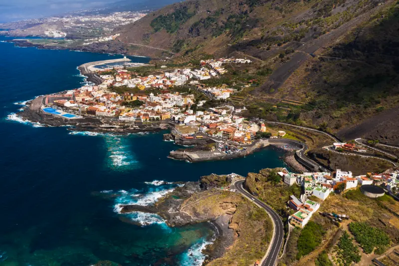
PR-TF 43 is one of the strongest mountain-to-volcano hiking lines in northwest Tenerife. It begins almost at Atlantic level in historic Garachico and climbs through lava-shaped slopes, rural land and pine forest until the Chinyero volcanic landscape takes over. The headline number is not the distance but the ascent: roughly 1,680 metres in 17.7 kilometres, which makes this a serious full-day effort rather than a casual add-on to a sightseeing day.
The technical figures below come from the current Turismo de Tenerife route information that I checked while preparing this guide. I still verify the live page before setting out, because status notices and temporary restrictions can change faster than an article.
Quick route facts
| Start | Garachico |
|---|---|
| Finish | Circular Chinyero |
| Type | Linear |
| Distance | 17.7 km |
| Official duration | 7 hr |
| Difficulty | High |
| Maximum altitude | 1,521 m |
| Minimum altitude | 46 m |
| Accumulated ascent | 1,680 m |
| Accumulated descent | 287.52 m |
| Protected areas | Acantilados de La Culata Protected Landscape; Chinyero Special Nature Reserve |
| Permit | No |
Why this route is worth understanding
What makes this route unusual is the vertical story. Garachico is inseparable from the 1706 eruption of Trevejo, and the walk gradually leaves the coast behind before reaching the younger Chinyero landscape associated with Tenerife’s 1909 eruption. I would choose it when the goal is to understand how volcanic history and settlement geography fit together, not simply to collect another summit.
For wider context I connect this route with Garachico guide Chinyero Volcano guide Arenas Negras trail Tenerife hiking permits and trail rules. I prefer building one coherent regional day rather than crossing the island between unrelated stops.
How the route unfolds
1. Garachico and the first sustained climb
The route leaves one of Tenerife’s most attractive historic towns and immediately asks for respect. The early ascent is where I deliberately keep the pace slow, because the legs are still fresh and it is easy to spend energy too quickly. Looking back toward the coast gives a clear sense of how rapidly the route gains height.

2. San Juan del Reparo and old lava terrain
The path climbs through the area of San Juan del Reparo and crosses terrain shaped by historical lava. This is not a smooth promenade: stone, uneven surfaces and steep gradients matter. I use this middle section to settle into a steady rhythm rather than chasing the official time.
3. La Montañeta and Arenas Negras
Higher up, the character becomes more rural and forested. The route approaches La Montañeta and the Arenas Negras area, where pines and volcanic soils replace the lower agricultural feel. My separate Arenas Negras guide is useful if I want a shorter alternative rather than committing to the entire PR-TF 43.
4. The Chinyero volcanic landscape
The final objective is the Chinyero area, where dark lava, pines and volcanic cones create one of Tenerife’s most distinctive hiking environments. I stay on the marked route because the reserve protects fragile terrain and because loose lava is much less stable than it can look from a distance.
Difficulty: how I read the official grade
The official difficulty label is useful, but I never use it alone. I combine it with distance, vertical gain or loss, altitude, exposure, trail surface and the amount of transport planning required. A short steep route can punish knees; a long descent can be exhausting; a high-altitude path can feel hard even when the gradient is moderate.
I also compare the route with my recent activity rather than with what I managed on a holiday years ago. If I have not been hiking regularly, I choose a shorter alternative first and learn how my body reacts to Tenerife’s heat, altitude and volcanic footing.
Navigation and route status
I use the current official route sheet as the baseline, then save an offline map before leaving. Waymarks matter more than a downloaded user track because old GPX files can preserve shortcuts, outdated diversions or sections that have since closed. At a junction I stop, confirm the marker and only then continue; following another group is not navigation.
Trail status can change after fire, heavy rain, maintenance or conservation work. I recheck the official page shortly before the hike. If a closure or prohibition is posted, I change plans rather than looking for a way around it. Tenerife has enough excellent alternatives that ignoring a closure is never necessary.
Getting there and getting back
Because the route is linear and finishes high in the Chinyero network rather than back in Garachico, I arrange the return before I start. A two-car shuttle, pre-arranged taxi or carefully checked bus plan is far safer than assuming transport will be easy after seven hours of climbing.
When buses form part of the plan I check the current TITSA timetable on the day itself. Rural services can be infrequent, and missing one bus after a long hike can turn a good day into a logistical problem. If I drive, I park legally and keep forest gates, farm access and emergency routes clear.
Weather and the best conditions
The route crosses several climate zones. Garachico can feel warm while the upper forest is cool, cloudy or windy. I carry a light insulating layer even on a sunny coastal morning and I avoid using the coast forecast as a proxy for conditions around 1,500 metres.
I check AEMET or another current mountain forecast rather than relying on the weather shown for a coastal resort. Calima, heat alerts, high wind, wildfire restrictions and rain are all valid reasons to change the route. Flexibility is one of the most useful pieces of hiking equipment I have.
What I carry
- Enough water for the route plus a reserve.
- Food that is easy to eat while walking, including something salty on longer days.
- Trail or hiking shoes with reliable grip.
- Sun protection: hat, sunscreen and sunglasses.
- A light windproof or insulating layer appropriate to the altitude.
- Offline map, charged phone and power bank for long routes.
- Small first-aid kit and any personal medication.
I adjust quantities to heat, altitude and duration rather than copying one packing list for every Tenerife walk. A five-kilometre route with 600 metres of ascent can require more water and recovery time than a flatter ten-kilometre walk.
Safety: the points I take seriously
I manage descents as carefully as climbs. Loose volcanic gravel, polished stone and tired legs are a common combination on Tenerife. I shorten my stride on steep ground, leave space between hikers and never hurry because someone behind me is moving faster. If I use trekking poles, I use them because I am already comfortable with them, not because the route suddenly feels difficult.
I stay away from cliff edges, ravine drops and unstable lava. I do not climb walls, cones or rock formations for photographs. During heat, calima, strong wind or heavy rain I shorten or cancel the walk. In an emergency the number in Spain is 112; I also tell someone where I am going and when I expect to finish.
Who this route suits
I think in terms of skills rather than labels such as “beginner” or “experienced”. The route is a good match only if everyone in the group is comfortable with its longest climb or descent, expected duration and surface. For families, I consider each child’s real walking experience and attention span rather than age alone.
If anyone is uncertain, I choose an easier route and keep this one for another day. Tenerife’s trail network is broad enough that scaling down does not mean wasting the trip.
Respecting the landscape
Many of these routes cross protected areas, working rural land or both. I stay on the signed path, close gates if the local system requires it, keep noise low near homes and never pick plants or collect volcanic rock. I carry out all rubbish, including organic waste, because food scraps can attract animals and change behaviour.
I also avoid creating social-media shortcuts. A line across loose lava or vegetation may look harmless when one person does it, but repeated footsteps can become a visible scar. The established route is part of the conservation system, not an obstacle to a better photograph.
Photography without compromising safety
I take photographs from stable, legal ground. Tenerife’s volcanic terrain creates strong foregrounds without needing to step beyond a barrier or onto a fragile slope. On exposed routes I secure loose items before taking out a phone or camera, especially in gusty wind.
I prefer a few deliberate stops to constant filming while walking. That improves both safety and the quality of the images: I can look at the route, notice geology and vegetation, and avoid turning every junction into a distraction.
How I would fit it into a Tenerife itinerary
I make the hike the main event of the day. Beforehand I keep breakfast and transport simple; afterwards I choose a nearby town, viewpoint or relaxed meal rather than another major attraction. This gives me margin for a slower pace, weather delays and the possibility that the trail takes longer than the official estimate.
For visitors staying far away, I would rather change accommodation for a night than add hours of driving before and after a demanding route. I compare accommodation around Garachico, Tenerife when the hike is one of the priorities of the trip.

Pacing, food and recovery
I eat before I am hungry and drink before I feel dehydrated. On long climbs I use small, regular snacks rather than a heavy meal. I also keep some food for the final hour; tiredness near the finish is exactly when concentration can drop.
After the hike I change out of wet layers if necessary, rehydrate and eat something substantial before driving a long distance. If the route has involved more than a thousand metres of ascent or descent, I avoid planning another demanding activity that evening.
Official information I check before leaving
The route page I use is Turismo de Tenerife’s official route information. I look for current status notices, closures, permit requirements and manager advice. If the route enters a national park or another managed protected area, I also check the relevant Cabildo or Tenerife ON information where applicable.
Common mistakes I avoid
- Starting late because the route looks short on a map.
- Using a beach forecast for a mountain or forest route.
- Assuming a linear trail will have simple transport at the finish.
- Following another hiking group instead of checking my own waymarks.
- Underestimating long descent and knee fatigue.
- Depending on mobile signal instead of saving maps offline.
- Leaving the marked trail for a shortcut or photograph.
- Ignoring a closure because an old blog or GPX shows the route as open.
Frequently asked questions
How long is the route?
The current official sheet lists 17.7 km. I use the official duration only as a reference and add time for breaks, navigation, photography and the pace of the slowest person in the group.
Do I need a permit?
The current route information shown in the table above is my starting point, but a permit and an opening status are different things. A route can require no permit and still be temporarily closed. I always check the live status immediately before the hike.
Can I hike it in ordinary trainers?
I prefer trail or hiking shoes with useful grip. Tenerife routes can combine loose volcanic material, polished stone, forest soil and rough steps. Heavy boots are not mandatory for every trail, but smooth urban soles remove a useful margin of safety.
What if the weather changes?
I use a turnaround point and a backup plan. If wind, heat, rain, cloud or fatigue materially reduces my safety margin, I turn back or switch plans. Completing a named route is never more important than returning with enough daylight and energy.
Is the official hiking time realistic?
It is a planning benchmark, not a promise. Fitness, photography, heat, route-finding and group size can all change the time. On demanding routes I add generous margin and avoid booking a fixed activity immediately after the expected finish.
Final thoughts
I see PR-TF 43 as a route for hikers who specifically want a large vertical day. Its reward is the transition from historic coast to volcanic highland, but that same transition creates the main challenge: sustained ascent, changing weather and complicated finish logistics.
The most useful approach is simple: check the official status, understand the vertical profile, plan the return before starting and keep enough margin to change the day when conditions are not right. That makes the route safer and usually more enjoyable.