
Casa de los Molinos is a useful stop for travellers who want to understand Tenerife beyond beaches and headline attractions. I would not cross the whole island only for this one place, but I would absolutely use it to add historical and local context to a day in Garachico.
In this guide I separate documented facts from practical planning. Dates, dimensions, artistic details and historical associations come from official tourism or municipal heritage sources. My suggestions about timing, route order, photography and combinations are travel-planning advice. I avoid inventing fixed opening hours, prices or guaranteed access when current official information is uncertain.
At a glance
| Place | Casa de los Molinos |
|---|---|
| Where | Esteban de Ponte, 64, 38450 Garachico |
| Best for | water heritage, traditional industry, volcanology and a compact Garachico walking route |
| Time to allow | 30–45 minutes, plus time for the surrounding historic centre |
| Planning rule | Combine it with nearby sights, verify current access and keep the route flexible. |
Why I would include Casa de los Molinos in a Tenerife itinerary
One of the easiest mistakes on Tenerife is to jump from one major attraction to another without understanding the towns between them. Places like Casa de los Molinos slow the trip down in a useful way. They show how local history, religion, trade, architecture, geology or landscape developed at the level of an individual community.
I also value stops that work inside a compact cluster. In Garachico, I can usually combine several worthwhile places without repeated driving. That gives me more time to notice details, stop for coffee, change plans if access is closed and still finish the day without feeling that I have been chasing a checklist.
My rule is simple: a small site earns its place when it helps explain the destination. I would rather spend thirty attentive minutes somewhere meaningful than add three generic viewpoints just to increase the number of stops.
What the official record confirms
- Official tourism information describes Casa de los Molinos as the only flour mill still standing in Garachico.
- The surviving mill remains in its original setting, now below present street level because of later urban development.
- The building contains an exhibition about Garachico’s volcanic activity.
- Other mills in the former complex were powered by water running through channels and disappeared during the 19th century.
Why a flour mill helps explain old Garachico
Garachico is usually introduced through the 1706 eruption and the loss of its port, but the Casa de los Molinos opens a different window onto the town. Before electric machinery and modern distribution, grain processing depended on a carefully managed water system. The mill was one piece of a network in which channels carried water through the settlement and converted gravity into useful power. Official tourism information notes that the other mills in the group disappeared in the nineteenth century, which makes the surviving example especially useful for understanding everyday infrastructure rather than only monumental architecture.
I like including the mill early in a walking route because it changes the way I read the rest of Garachico. Water, slope and street level suddenly matter. The fact that the building now sits below the modern street also shows how towns accumulate layers. Instead of treating that lower position as an oddity, I use it as a clue to later urban change and to the relationship between historic engineering and the town visitors see today.

The volcanology exhibition belongs here more than it first appears
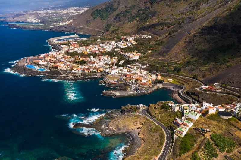
At first, a volcanology display inside a flour mill may sound like two unrelated subjects. In Garachico they fit together. The town’s history is inseparable from volcanic processes, especially the eruption of 1706, while the mill itself belongs to an older landscape shaped by gradients, water courses and settlement patterns. The exhibition therefore gives useful context for why the town looks the way it does and why the coastline, port history and inland routes cannot be understood separately.
I would not expect a huge science museum. I approach the visit as a compact interpretation stop that adds context before seeing lava-formed places outside. Afterwards, El Caletón and the higher viewpoints make more sense because I have a clearer picture of how volcanic activity affected both the built town and its economic history. For families, this sequence can also make a heritage walk more varied than moving from one church façade to another.
How I build the mill into a half-day route
My preferred order is to park once, explore the historic core on foot and use Casa de los Molinos as one of several short stops. I would pair it with the Puerta de Tierra area, Plaza de la Libertad, Santa Ana and the waterfront rather than planning a separate drive. If the weather is calm, El Caletón can finish the route; if the sea is rough, I keep the visit entirely cultural and add a viewpoint instead.
The mill is also a good anchor for travellers interested in hiking history. Garachico’s steep relationship with the upper slopes becomes obvious when I later look toward the routes climbing inland. I would not combine a demanding PR-TF 43 hike and a dense old-town visit unless I had a full day and good fitness, but the mill provides a useful historical preface to the island’s network of water, agriculture, trade and mountain paths.
What to combine with it nearby
I would build the visit around nearby pages already covered on this site rather than create an isolated detour. Good combinations include El Caletón, Mirador de Garachico, PR-TF 43 Garachico–Chinyero. For a broader planning option, I also keep Isla Baja guide in the same cluster.
How I plan the visit
I start by deciding whether Casa de los Molinos is the anchor of the outing or a supporting stop. For a small heritage or nature site, the second option is usually better. I allow enough time to read information, look at details and take a few photographs, but I do not turn a short visit into half a day simply because the itinerary has empty space.
I then check the official source shortly before travelling. Religious services, conservation work, local events, sea conditions, trail restrictions, seasonal timetables or staffing can change access. If one element is unavailable, I want the surrounding route to remain worthwhile.
- Start with the most time-sensitive stop, such as a museum, church interior or safe coastal window.
- Continue on foot to exterior heritage, public squares, paths or viewpoints.
- Keep lunch or coffee flexible so a delay does not break the itinerary.
- Leave the final stop optional, especially if traffic, weather or a local event changes the pace.
This style of planning works particularly well in Tenerife’s northern towns. Short map distances can hide steep streets, difficult parking, wet paths or strong Atlantic conditions, while a compact regional loop often reveals much more than several rushed car stops.
How I read the history without oversimplifying it
Heritage sites often mix documented facts, later restoration, local tradition and popular legend. I try to keep those layers separate. A date recorded by an official heritage inventory is not the same kind of evidence as a story passed through generations, even though both can be valuable for understanding the place.
I also avoid treating Tenerife’s colonial period as a neutral backdrop. Conquest, Indigenous Guanche history, Atlantic trade, migration, agriculture and religious institutions all shaped the island. Where one of those themes is relevant to Casa de los Molinos, I name it directly rather than reducing the story to decorative architecture.
What I look for on site
Before reaching for my phone, I look at materials and relationships: volcanic stone, timber, limewashed walls, ironwork, paving, water channels, old trees, surf patterns or the way a building faces a square. These details usually tell me more than a single façade photograph.
I also pay attention to later changes. Historic places are rarely frozen in one century. Fires, floods, new roads, restorations, changing religious use, domestic water systems and civic adaptation can all become part of the story. I find a place more interesting when I can see those layers rather than searching for an imaginary “original” version.
Getting there and moving around
For Garachico, I compare driving with public transport according to the rest of the day. A car is helpful when I am continuing to rural viewpoints or another municipality, but it can be inconvenient in older streets with limited parking. If I am concentrating on a historic centre or marked coastal area, I prefer to park once and walk.

TITSA serves the main towns and tourist areas of Tenerife. I check the current journey planner instead of hard-coding a bus number into an evergreen article, because routes and stops can change. Travellers with a pushchair, luggage or limited mobility should also inspect the final approach: gradients, cobbles, steps and natural rock often matter more than the intercity journey.
Best time of day
For architecture and street photography, morning or late afternoon usually gives softer light. For a church or museum, access arrangements matter more than the angle of the sun. For beaches, natural pools and exposed paths, tide, swell, wind and rain matter more than a fixed clock time.
Weekends, feast days and local events can transform a quiet place into a busy community space. That can be a highlight if I want atmosphere, but it can also affect parking and access. I check local notices when travelling around major religious, municipal or coastal events.
Practical tips that make the stop better
Comfortable shoes are my default even for short visits. Historic paving can be uneven, north-Tenerife towns often have steeper streets than a map suggests and volcanic coastal rock can be slippery. I carry water and a light layer because cloud, breeze and sun can change quickly across short distances.
I do not assume that a public-looking heritage building has toilets, step-free access or continuous opening. Travellers who need specific accessibility features should verify them directly with the venue or municipality. At natural sites I also check whether the final approach is suitable for the whole group.
For churches and devotional spaces, I dress respectfully and keep noise low. For schools or working cultural sites, I follow access instructions. On beaches, pools and protected volcanic terrain, I stay within legal access and never treat calm-looking water as proof that swimming is safe.
Photography without missing the place itself
I take one wide establishing image, then look for details: stonework, wood, metal, inscriptions, paving, water infrastructure, vegetation or the relationship between geology and human use. That produces a more useful visual record than ten almost identical front-on photographs.
I never assume drone use is legal simply because a place looks quiet. Tenerife has controlled airspace, protected areas and populated zones. A travel guide cannot replace current aviation rules or local restrictions.
Where to eat and how I fit meals into the route
I prefer eating near the area I am already exploring instead of driving across the island for a single restaurant. In Garachico, that might mean a café in the historic centre, a traditional Canarian lunch or a longer meal after the walking portion of the day. I check recent opening information because weekly closing days and kitchen hours change.
Local food makes more sense when connected to the place: papas arrugadas, mojo, gofio, cheeses, fish and Tenerife wines all reflect agriculture, trade and everyday island life. I would rather choose a simple meal that fits the route than interrupt the day for a famous restaurant far away.
Where to stay
If I want to explore this part of Tenerife over more than one day, I compare current accommodation on Booking.com. I pay attention to the exact map position, parking, elevation and recent guest comments rather than relying only on the property name.
For a first visit, I choose a base according to the majority of the itinerary. A good location saves more time over a week than staying next to one small attraction that I will visit only once.
Activities and tours
A heritage or nature stop can pair well with one organised experience elsewhere on the island. I use the widget below to compare current options, but I avoid stacking a long excursion immediately before or after a dense driving day.
Who will enjoy this stop most?
Casa de los Molinos is best for travellers who enjoy context rather than only headline attractions. Couples and solo travellers can fold it into a slow regional day; families can use it as a short educational stop when access and terrain are suitable; repeat visitors may appreciate it because it reveals a layer of Tenerife that is easy to miss on a first trip.
It may be less useful for someone with only a few hours on the island who is still trying to prioritise Teide, Anaga or a major beach. I would rather say that clearly than label every place a “must-see”. A good guide should help readers decide what fits their interests.
Common mistakes I would avoid
- Driving across Tenerife only for this single stop without combining it with the surrounding area.
- Assuming old opening hours, trail information or sea conditions are still valid.
- Underestimating gradients, parking limitations, wet rock or narrow historic streets.
- Treating local legends as proven history without saying they are traditions.
- Ignoring services, worship, school security, safety signs, closures or private boundaries because a place appears visitor-oriented.
Frequently asked questions
What is Casa de los Molinos in Garachico?
It is the only surviving flour mill from Garachico’s former water-powered mill complex, according to the official tourism page.
Why is it below street level?
Official information explains that later urban development left the original mill site below the present level of the street.
What can I learn there?
The site combines traditional milling heritage with an exhibition about the municipality’s volcanic activity.
Is it worth a special trip?
I would visit it as part of a Garachico historic-centre walk rather than drive across Tenerife only for the mill.
Official information
For the documented background used in this guide and for any current operational information, I check the official visitor or heritage information for Casa de los Molinos shortly before travelling. Same-day signs, staff instructions, parish notices, municipal updates, sea warnings and safety restrictions always take priority over an evergreen article.
Final thoughts
I would include Casa de los Molinos when it strengthens the story of a day in Garachico. Its value is not measured by how many hours it occupies. A short stop can be meaningful when it explains architecture, faith, trade, geology, water, landscape or everyday life.
My preferred approach is simple: know the key facts before arriving, stay flexible about access, respect the place as part of local life and connect it with nearby sights. Done that way, it becomes one more piece of a Tenerife itinerary that feels coherent rather than crowded.