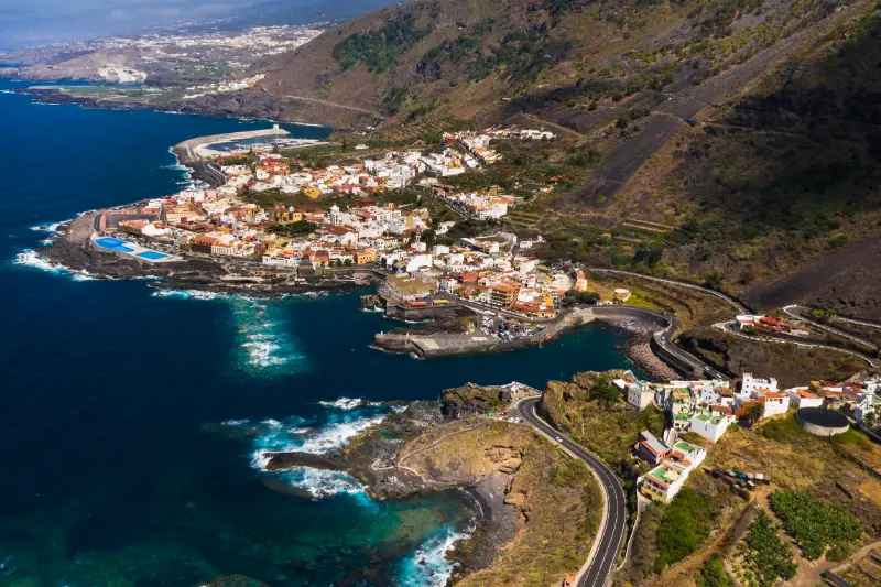
Mirador de Garachico is a viewpoint I would include when I want to understand this part of Tenerife rather than simply collect another photo stop. It sits in San Juan del Reparo above Garachico, on or close to the road between Icod de los Vinos and Guía de Isora, and the official or municipal tourism information highlights a broad panorama over Garachico, the Atlantic coast and the ravine-like channels through which lava descended during the 1706 eruption.
Few viewpoints explain Garachico’s history as directly: the height makes it easier to see how volcanic terrain, cliffs and settlement fit together. I plan the stop as part of Garachico, San Juan del Reparo and the TF-436/TF-82 mountain roads, not as a reason to cross the whole island for ten minutes. That keeps the day realistic and leaves time to respond to cloud, traffic and changing light.
Quick planning facts
| Viewpoint | Mirador de Garachico |
|---|---|
| Area | San Juan del Reparo above Garachico |
| Road / position | the road between Icod de los Vinos and Guía de Isora |
| Landscape | around 460 metres above the north coast according to the municipal tourism description |
| Main views | a broad panorama over Garachico, the Atlantic coast and the ravine-like channels through which lava descended during the 1706 eruption |
| Parking | I use only designated or clearly legal parking because the road is also a working mountain connection |
| Bus | I check current TITSA options rather than assuming a stop directly at the viewpoint |
| Accessibility | conditions can change with the venue and road, so I verify before relying on step-free access |
Why I would stop here
The best Tenerife viewpoints do more than provide a wide angle. They explain the island. At Mirador de Garachico, I can compare elevation, vegetation, roads, towns and volcanic shapes in one frame. That makes the stop useful before visiting the places below because I arrive with a clearer mental map rather than following turn-by-turn navigation without understanding the landscape.
I normally stay longer than the few minutes suggested by a quick road itinerary. Ten minutes is enough to photograph the view, but twenty to forty minutes gives cloud and light time to change. On Tenerife, a ridge hidden at arrival can appear suddenly, while a clear panorama can disappear behind cloud just as quickly.
What I can see
The main panorama includes a broad panorama over Garachico, the Atlantic coast and the ravine-like channels through which lava descended during the 1706 eruption. I look for layers instead of trying to identify every landmark immediately: foreground vegetation or rock, middle-distance towns and ridges, then the highest peaks or distant coast. This approach makes the view easier to understand and usually creates better photographs than zooming straight toward the most famous feature.
Visibility is never guaranteed. Trade-wind cloud can cover the north and northeast, haze can soften the south, and calima can reduce long-distance contrast across the island. I treat a cloudy visit as a different landscape rather than automatically a failed one, but if the entire purpose of the stop is photography I check current weather, webcams where available and mountain conditions before driving up.
Getting there
Mirador de Garachico is associated with the road between Icod de los Vinos and Guía de Isora. Tenerife road distances can be misleading because bends, elevation and slower local traffic matter more than kilometres. I add margin to the navigation estimate and avoid scheduling a fixed attraction immediately after the viewpoint. On narrow or mountain roads I keep attention on driving and let passengers enjoy the scenery until I am safely parked.

I use only designated or clearly legal parking because the road is also a working mountain connection. Even when parking is provided, I do not stop outside marked or obviously legal areas if the car park is full. Blocking a mountain road, farm entrance or bus movement for a photograph creates unnecessary risk. If the stop is busy, I either wait briefly or continue to another planned viewpoint.
Public transport and no-car planning
I check current titsa options rather than assuming a stop directly at the viewpoint. Where a bus stop exists, I still check the current TITSA timetable and the direction of the stop before relying on it. Mountain and rural services can be much less frequent than resort routes, and a missed connection can turn a short stop into a long wait.
If there is no convenient stop, I do not improvise by walking along a road without a pavement. For a no-car trip, I would rather choose viewpoints connected to established trails or frequent bus corridors. The goal is not to prove that every place is possible without a car; it is to build a safe route around the places that genuinely work.
Accessibility
Conditions can change with the venue and road, so i verify before relying on step-free access. I treat this as a starting point, not a guarantee for every traveller. Gradients, kerbs, the distance from parking to the rail, toilet availability and the surface itself can determine whether a viewpoint is comfortable for someone using a wheelchair, walker or cane.
Before travelling specifically for accessibility, I verify current conditions with the official site or local authority. Temporary works, parked vehicles or a closed terrace can change a visit even when the permanent infrastructure is described as adapted.
Using the view to read Garachico’s volcanic history
The 1706 eruption is central to Garachico’s story, but the useful part of this stop is spatial understanding. From above, I can better imagine lava descending from higher ground toward a coastal settlement and changing its harbour and urban geography. I avoid turning a destructive historical event into spectacle; the point is to connect the physical terrain with what happened to people, trade and the town.
Best time of day
I choose timing according to the direction of the view rather than repeating a generic “sunset is best” rule. Morning can bring cleaner air and quieter roads; afternoon can warm colours on ridges; sunset may be dramatic but can also put key features into silhouette. For valley and mountain viewpoints, cloud development is often more important than the clock.
If photography matters, I would rather visit twice on a longer stay than wait hours for perfect light on a single day. Tenerife has strong microclimates. A disappointing first stop does not mean the viewpoint is overrated; it may simply mean the air mass and cloud level were wrong at that moment.
Photography tips that actually help
I start with a wide composition to show scale, then use a moderate zoom for layers of ridges, towns or volcanic cones. A polarising filter can sometimes help with glare, but it can also create uneven skies with very wide lenses, so I use it carefully. On a phone, I avoid excessive digital zoom and instead make several clean compositions that I can crop later.

I keep the camera strap secure in strong wind and never cross a barrier to remove a foreground object. A railing or pine branch can become part of the composition. The best photograph is not worth standing on an unstable edge, stepping into the road or damaging vegetation.
Weather, wind and cloud
Conditions at around 460 metres above the north coast according to the municipal tourism description can differ sharply from the coast. I carry a light layer even when the beach is warm, and in winter I add something more substantial if the route climbs high. Wind is often the most noticeable factor because a temperature that seems mild can feel cold after several minutes in an exposed position.
Cloud is equally important. Northern slopes frequently interact with the trade-wind layer, producing the famous sea of clouds at some elevations while covering lower valleys at others. In the south and east, haze or calima can be the bigger issue. I check the forecast for the actual elevation rather than using only a resort forecast.
How long I would stay
For a simple road stop I allow twenty to forty minutes. That is enough to park without rushing, read any interpretation, take photographs and actually look at the landscape. If there is a café, short trail or historical element, I extend the stop to an hour or more.
I do not build a day around visiting ten viewpoints. After the third or fourth, the landscapes begin to blur together. My preference is two or three contrasting stops linked to towns, a walk, a meal or a museum. That produces stronger memories and much less driving.
How I combine it with the rest of the day
I would pair Mirador de Garachico with Garachico, San Juan del Reparo and the TF-436/TF-82 mountain roads. The important thing is geographical logic: I continue in the same area instead of zigzagging across Tenerife because another attraction looked close on a map.

If the weather changes, the viewpoint becomes the flexible part of the itinerary. I can shorten it, move it later or replace it with a town stop. This is one reason I like viewpoints: they add a high-value experience without requiring a fixed entrance slot.
Food, toilets and practical stops
I never assume a viewpoint has toilets, drinking water or an open café unless current information specifically confirms it. I use facilities in the nearest town before a long mountain section and carry water in the car. If a café is part of the site, I still check opening hours rather than treating it as guaranteed.
For food, I prefer to connect the stop with a local town or market rather than eating only at roadside places. This turns the view into part of a broader regional day and spreads visitor spending more naturally across the communities I pass through.
Safety at viewpoints
Barriers, marked paths and parking rules are part of the experience, not obstacles to a photograph. I stay behind rails, keep children close near drops, and do not sit on walls above cliffs. Strong wind can affect balance and can also pull hats, phones or loose objects from my hands.
I am especially careful when leaving a parking area. Some viewpoints sit on roads where traffic accelerates immediately after a bend. I look both ways, avoid standing in the carriageway and wait for a safe gap rather than trying to photograph from the road itself.
Responsible visiting
I take all rubbish away, keep noise low and avoid trampling vegetation to create a private photo spot. At rural viewpoints I also respect houses, farms and access tracks nearby. A viewpoint may be on a tourist map, but the surrounding area is often part of someone’s everyday working landscape.
Drone use deserves extra caution because protected areas, airports, wildlife and local restrictions can make a seemingly empty viewpoint unsuitable or illegal for flying. I check current Spanish aviation rules and protected-area restrictions before bringing a drone into the plan.
Common mistakes I would avoid
- Driving across the island only for a five-minute stop.
- Using a coastal weather forecast for a high-elevation viewpoint.
- Parking on the road when the designated area is full.
- Assuming a visible beach or trail is automatically safe or accessible.
- Crossing barriers for an unobstructed photograph.
- Trying to visit too many viewpoints in one day.
Is Mirador de Garachico worth it?
For me, yes when it fits the route. The value comes from context: Few viewpoints explain Garachico’s history as directly: the height makes it easier to see how volcanic terrain, cliffs and settlement fit together. I would not make a long cross-island detour solely to tick it off, but as part of Garachico, San Juan del Reparo and the TF-436/TF-82 mountain roads it adds perspective that a beach, town street or hiking trail cannot provide on its own.

My final rule is to let conditions decide the length of the stop. If the view is clear and the light is changing, I stay. If cloud closes in completely or parking is chaotic, I move on without forcing the experience. Tenerife rewards flexible travel more than rigid checklists.
Final planning checklist
Before I leave, I check the road, weather at the correct elevation, daylight, any local closures and the next stop in the route. I carry water, sun protection and a layer, download the map in case coverage drops and keep enough fuel for mountain driving. That small amount of preparation lets me enjoy Mirador de Garachico as a landscape experience rather than another logistical problem.