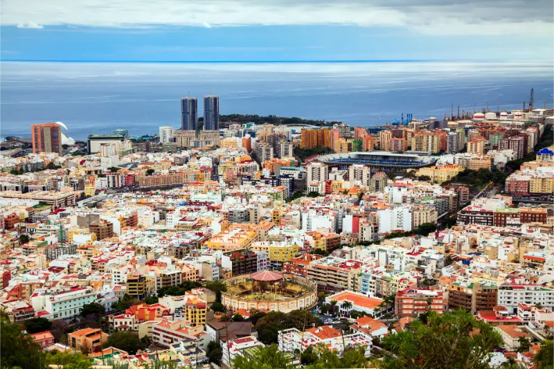
Mirador de Montaña Grande El Rosario is one of the Tenerife stops I would use to go beyond the island’s headline attractions. Mirador de Montaña Grande is one of the most useful TF-24 viewpoints because the panorama explains Tenerife’s geography in several directions at once. The clearing opens in a pine forest as the road climbs toward the Teide highlands. From here official tourism information points out Santa Cruz, the agricultural zone of El Rosario and the angular relief of Anaga; looking south, the view can extend toward Malpaís de Güímar and even El Médano. I would use it as an orientation stop rather than simply a photo stop.
In this guide I separate documented facts from planning advice. Historical or descriptive details come from official tourism or municipal information, while suggestions about timing, parking, combinations and pace are my practical way of building a realistic Tenerife day. I deliberately avoid inventing fixed opening hours when the responsible source does not publish a reliable current schedule.
At a glance
| Area | El Rosario |
|---|---|
| Best for | travellers interested in local history, landscape and a more detailed Tenerife itinerary |
| Time to allow | 20–60 minutes for the core stop; 2–4 hours with nearby places |
| My planning rule | combine it with the same area rather than crossing the island for one small attraction |
Why this place deserves a dedicated guide
Mirador de Montaña Grande is one of the most useful TF-24 viewpoints because the panorama explains Tenerife’s geography in several directions at once. The clearing opens in a pine forest as the road climbs toward the Teide highlands. From here official tourism information points out Santa Cruz, the agricultural zone of El Rosario and the angular relief of Anaga; looking south, the view can extend toward Malpaís de Güímar and even El Médano. I would use it as an orientation stop rather than simply a photo stop.
What the official record confirms
The viewpoint is on the TF-24 at approximately kilometre point 13 in El Rosario.
It opens from a pine forest with mature trees.
Views include Santa Cruz de Tenerife, agricultural areas of El Rosario and the Anaga mountains.
Looking south, Turismo de Tenerife notes panoramas toward Malpaís de Güímar and El Médano.
The official viewpoint information lists parking and disabled access.
An interpretive panel or table is provided, while the official listing indicates no bus stop at the viewpoint.
What I would pay attention to
I would use the interpretive panel before taking photographs because the value of the view is in identifying landscape zones. Santa Cruz and the metropolitan coast sit very differently from the folded mountains of Anaga, while the agricultural slopes of El Rosario form another layer entirely. On a clear day the southern view adds the dry volcanic landscape around Güímar and the coast beyond. On a cloudy day, the pine forest itself can still be atmospheric, but I would not force a long wait if the cloud deck is clearly persistent.
I also spend a minute looking at what sits around the site. Tenerife’s heritage and landscapes are rarely isolated from topography. Ravines determined movement, water shaped agriculture, altitude affected crops, ports responded to the sea and building materials came directly from volcanic terrain. Reading that setting helps me understand why a place exists where it does instead of reducing the visit to dates and names.
How to read the panorama
The easiest way to understand this viewpoint is to divide the panorama into three stories. The metropolitan story is Santa Cruz and the developed coast. The agricultural story is El Rosario, where cultivated land sits between settlement and forest. The geological story is the mountain relief of Anaga and the volcanic terrain visible toward Güímar. Seeing all three from one place makes Tenerife feel less like a collection of separate attractions and more like a connected island system.

I also watch the cloud base. The trade-wind layer can hide one direction while leaving another completely open. That is normal rather than a failed visit. If visibility matters, I check webcams and the highland forecast before committing to a longer drive up the TF-24.
How I would combine it with nearby places
This stop fits naturally into a TF-24 day. I would pair it with La Esperanza, Bosque del Adelantado or Las Raíces rather than descending and climbing repeatedly. If I am heading farther toward Teide National Park, I treat Montaña Grande as the first landscape-reading stop and keep later viewpoints for different altitude zones. That prevents the common mistake of stopping at every lay-by until all the views begin to feel identical.
- El Rosario Tenerife guide
- Bosque del Adelantado guide
- Las Raíces recreation area guide
- Nuestra Señora de La Esperanza church
How I would plan the visit
I treat this outdoor site as part of a geographically compact day. Tenerife looks small on a map, but steep roads, motorway traffic and very different weather by altitude can turn a simple list of stops into too much driving. My rule is to choose one municipality or one landscape corridor and let nearby places build the story.
I also distinguish between what is always visible from public space and what depends on opening hours, authorised access, sea state or weather. Small chapels and historic houses can change access; forest facilities can be restricted during high fire risk; viewpoints can disappear into cloud; coastal activity changes with wind and swell. I verify operational details shortly before travelling instead of publishing a timetable that may age badly.
Best time of day
Morning is usually my easiest choice for these stops. Parking tends to be calmer, I have time to change the plan if access differs from expectations, and light is often easier for architecture or landscape photography. On the coast I also check wind and sea conditions; in the uplands I care more about cloud base, recent rain and fire restrictions.
If the place is active religious heritage, I avoid visiting in the middle of worship simply because a door is open. If it is a protected natural or military site, I do not treat open ground as permission to climb, enter structures or leave established routes. The best time is the one that combines respectful access, safe conditions and enough daylight for the rest of the route.
Getting there and parking
I use the official address or map position as an orientation point, then follow local signs for the final approach. Historic streets, forest roads and residential areas are exactly where navigation apps can suggest an impractical shortcut. I never block a resident entrance, farm track, church doorway or emergency route for the sake of saving a five-minute walk.
Public transport works for several town and coastal stops, but upland recreation areas and viewpoints can be less convenient without a car. I check the current TITSA journey planner close to the date of travel. If I drive, I save the parking location before walking away; steep streets and similar-looking lanes can make the return less obvious than expected.
Visiting with children
For families, I keep the explanation concrete. I ask children to notice one thing: a carved doorway, an unusual façade pattern, the shape of a pine cone, a marina crane, a bunker view or the difference between coast and monteverde. A short focused stop followed by a picnic, viewpoint or easy walk usually works better than stacking several heritage interiors in succession.
I also keep safety specific to the setting. Old streets can be steep and uneven; forest ground can hide roots and loose needles; coastal viewpoints can be windy; marinas have moving boats and operational areas; historic military structures can have drops or rough concrete. I keep children close where terrain or activity requires it.
Accessibility and comfort
I never assume that “close to the road” means step-free. Historic buildings can have thresholds, old paving or narrow doors, while outdoor sites may involve slopes and uneven ground. Where an official viewpoint specifically lists accessible access I still check current conditions if step-free use is essential.
I carry water, sun protection and a light layer year-round. El Rosario can shift quickly from a mild coast to cool pine forest, while Santa Úrsula can be humid on the coast and much cooler in its upper neighbourhoods. That vertical climate change is easy to underestimate when the driving distance is short.
Photography and respectful behaviour
I photograph from public space unless access is clearly permitted. I do not cross gates, climb walls, enter closed military structures, move museum objects or step onto private agricultural land for a cleaner composition. At religious sites I keep my voice low and put the camera away during worship.
At natural sites I use photography as a reason to observe, not to leave the route. The details that usually make the strongest images—texture, vegetation, changing cloud, boats, cliffs and layers of terrain—can be seen without damaging the place.
Food and a slower local day
Both El Rosario and Santa Úrsula reward a slower local lunch instead of a rushed cross-island itinerary. Radazul has a very different food setting from upland La Esperanza, while Santa Úrsula is closely associated with wine culture, guachinches and north-Tenerife cooking. I keep a second option in mind because smaller restaurants and guachinches can have changing weekly opening days.
For picnic areas I take rubbish away even when bins are present, avoid feeding wildlife and check fire regulations before using any cooking facility. A recreation area is shared infrastructure, not a private campsite.
Where to stay nearby
If this part of Tenerife is a priority, sleeping nearby reduces motorway time and makes morning visits easier. I compare the exact property location as carefully as the town name because slopes can turn a short map distance into a steep walk. Compare accommodation around El Rosario on Booking.com.
Tours and activities
For travellers who want to add a guided experience elsewhere on the island, I compare current tours rather than hard-coding one product that may disappear or change. The widget below can surface available Tenerife activities while this article remains focused on the specific place.
Common mistakes I would avoid
- Driving across Tenerife for one small stop instead of building a local cluster.
- Assuming an interior is open because the exterior is publicly visible.
- Entering a closed bunker, restricted forest area, private estate or operational marina zone.
- Using old blog opening hours instead of checking an official source.
- Ignoring cloud, recent rain, wind, swell or fire-risk restrictions.
- Treating a working neighbourhood or devotional place like a theme-park attraction.
A realistic half-day itinerary
- Arrive early enough to park legally and understand the setting before rushing to photos.
- Spend the first part of the visit on the main site, using official interpretation where available.
- Walk or drive only a short distance to one or two related places in the same cluster.
- Take a coffee, lunch or picnic break locally.
- Use the final hour for a viewpoint, coast stop or easy walk only if weather and access are good.
This loose structure is more useful to me than a minute-by-minute plan. It gives room for an interior that is unexpectedly closed, a cloud layer that changes a viewpoint, a forest restriction, a rougher sea or a local event. Tenerife travel becomes easier when I plan a strong cluster and a flexible order.
Why these smaller Tenerife stops are worth including
El Rosario and Santa Úrsula both show how much variety Tenerife can pack into short distances. In El Rosario I can move from a marina and diving coast to pilgrimage heritage and pine forest. In Santa Úrsula, nineteenth-century decorative architecture, old estates, a modern landscaped sculpture, military history and monteverde all sit within one municipality.
That scale makes a trip feel less like a checklist. Instead of spending the day moving only between famous ticketed attractions, I can walk, look, stop for food and understand how people used the same terrain for agriculture, worship, transport, defence, recreation and community life. For repeat visitors to Tenerife, these layers are often what make another trip feel genuinely different.
Frequently asked questions
Where exactly is the viewpoint?
Turismo de Tenerife places it on the TF-24 at approximately kilometre point 13 in El Rosario.
Is there parking?
Yes. The official viewpoint listing indicates parking is available.
What can I see?
The documented panorama includes Santa Cruz, El Rosario farmland and Anaga, with views south toward Malpaís de Güímar and El Médano in suitable conditions.
Is there public transport at the viewpoint?
The official listing says there is no bus stop at the viewpoint, so a car is the simplest option for most visitors.
Official information
For the documented facts and the latest operational information, I check Turismo de Tenerife – Mirador de Montaña Grande shortly before travelling. Local events, restoration, weather, fire restrictions, sea conditions and access can change after an article is published, so the official source always takes priority for same-day conditions.
Final thoughts
I would not describe every small Tenerife stop as a universal “must-see”. That language is not helpful. The value of Mirador de Montaña Grande El Rosario is that it adds a precise layer to the island and makes a local cluster richer. When several of these places are combined, the municipality stops being a name on the motorway and becomes a destination with its own history, landscape and rhythm.
My preferred approach is simple: know the key story before arriving, keep the visit respectful, stay flexible about access and spend enough time in the surrounding area for the place to make sense. That is how a small stop becomes useful rather than just another pin on a map.