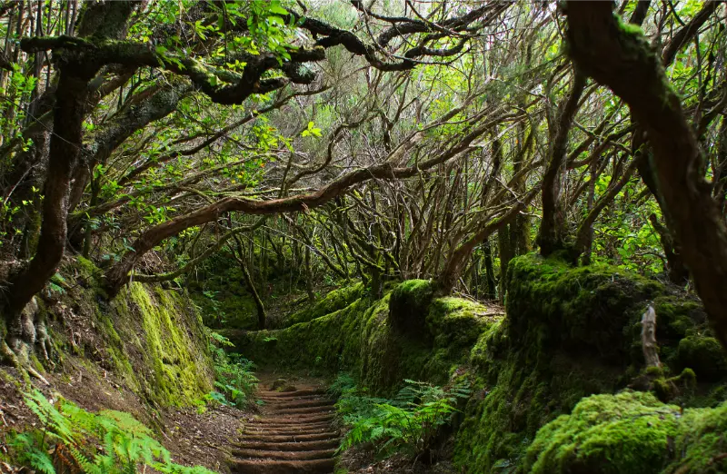
The Sendero de los Sentidos is one of the best introductions to Anaga for travellers who want the atmosphere of laurel forest without committing to a long mountain hike. It starts at Cruz del Carmen and offers three short interpretive routes through monteverde. The shortest is adapted for people with motor or sensory disabilities, while the longer options add old paths, steps, slopes and a viewpoint. This guide is built around the details I would want before leaving my accommodation: what is actually worth my time, how I would get there, where the friction points are, and what I would combine with the visit without turning the day into a race.
Quick planning facts
| Start | Cruz del Carmen, Anaga Rural Park |
|---|---|
| Route 1 | 340 m; low difficulty; adapted boardwalk/terrace |
| Route 2 | 544 m; low difficulty; about 20 m elevation change |
| Route 3 | 1,272 m; low–medium difficulty; steeper sections; about 100 m elevation change |
| Environment | Laurisilva/monteverde forest |
| Planning source | Check Tenerife ON for current trail status before travelling |
The first thing I would do is open the Tenerife ON trail information. I use the official source for the elements most likely to change — opening times, admission, access restrictions or temporary closures — and use the rest of my itinerary as a flexible framework. Even short trails in Tenerife deserve real outdoor planning. Cloud, drizzle and wind can arrive in Anaga while the south coast remains sunny, and forest surfaces can stay damp long after rain. I check Tenerife ON for current conditions, wear closed shoes with grip and keep to the marked route rather than following informal shortcuts.
Why I would put Sendero de los Sentidos on an itinerary
Anaga can be intimidating on a first visit because its roads, cloud and steep terrain look serious compared with the resort coast. The Sendero de los Sentidos gives me a controlled first step into that landscape. I can experience damp laurel forest, old path surfaces and changing light without needing a full trekking day.

The interpretive concept is also unusually good. Instead of simply telling me the names of plants, the route encourages sight, smell and touch where appropriate. That turns a short walk into something more memorable, especially for children and travellers who are not regular hikers.
What the experience is really like
Cruz del Carmen sits high enough for cloud to be completely normal. I might begin in bright sun near La Laguna and arrive twenty minutes later in mist, drizzle and cool air. I see that as part of Anaga rather than bad luck. The forest is adapted to moisture, and the shifting atmosphere is central to its character.
The three routes are not interchangeable. Route 1 is the accessibility-focused option; route 2 adds more traditional trail elements; route 3 reaches farther into the forest and includes stronger gradients. I choose the route that matches the least confident person in my group, not the one that sounds most impressive.
Route 1: the accessible sensory trail
The first route is about 340 metres and uses a boardwalk with a small terrace. It was designed for people with motor or sensory disabilities and is the obvious starting point for families with prams or visitors who need a more controlled surface.
I still check current conditions because wet wood can feel different from a dry promenade, and accessibility is always personal.
Route 2: a little more texture
The second option is a 544-metre circular walk that follows part of an old mountain path, with historic surfaces, steps, a bridge and elevated walkway.
This is the route I would choose when I want more of a “real trail” feel but still have limited time or modest hiking experience.
Route 3: deeper into the monteverde
At roughly 1.272 km, the third route is still short by hiking standards but has around 100 metres of elevation change and sections of steeper slope. It also reaches the Llano de los Loros viewpoint.
I would wear proper closed shoes, especially in mist. Short distance does not automatically mean dry or flat terrain.
Cruz del Carmen itself
The trailhead is more than a car park. The visitor-centre area and viewpoint help me understand where Anaga sits in relation to La Laguna and the north-east of Tenerife.
I spend a few minutes orienting myself before walking because context makes the forest more meaningful.
The forest atmosphere
The real highlight is not a single viewpoint but the laurisilva environment — trunks, leaves, moisture, filtered light and the muffled sound of a dense forest.
I deliberately put the phone away for sections of the route. A “sensory” trail loses its point if I experience it only through a camera screen.
How I would get there
I can reach Cruz del Carmen by road from La Laguna, but parking is limited and popular periods can be busy. I would arrive early, especially at weekends, and never park in a way that blocks traffic or access.
Public transport can be a good alternative from La Laguna depending on the current timetable. I check TITSA on the day rather than copy bus numbers from an old article because routes and frequencies can change. If I am comparing transport options across the island, I use my getting around Tenerife guide and, for road-based days, my Tenerife by car guide rather than relying on a route estimate that ignores parking, mountain roads or the walk from the final stop.
How much time I would allow
The shortest route can be walked quickly, but I would not visit only to record a ten-minute time. I allow at least an hour for the first trail, interpretation, viewpoint and simple wandering around Cruz del Carmen.
For route 3 I would keep around 60–90 minutes available, more with children or photography. The larger Anaga day then depends on whether I continue toward Taganana, another trail or La Laguna.
When I would go
Morning is my favourite because parking pressure is lower and I still have options if cloud becomes dense. In summer the forest can be a refreshing contrast to the south; in winter I expect cooler, wetter conditions.
I do not cancel simply because the forecast shows cloud. I cancel or change plans for genuinely unsafe weather, closures or warnings. Mist is often part of the experience; heavy wind, intense rain or official restrictions are different. For the broader seasonal picture, my best time to visit Tenerife guide explains why conditions can differ so much between coasts and elevations.
Families, accessibility and different travel styles
This is one of the easiest nature introductions for families because I can choose a route by age and confidence. I keep children close, explain that the forest floor and plants are protected, and turn the sensory signs into a game without encouraging them to leave the trail.

Route 1 was specifically designed to be accessible for people with motor or sensory disabilities. I would still check Tenerife ON and the visitor centre if I need guaranteed step-free conditions, because maintenance or weather can temporarily affect any outdoor route. I never assume that the words “easy” or “accessible” mean the same thing for every traveller, so I check gradients, surfaces, toilets, shade and the distance from parking or public transport. My accessible Tenerife guide gives the wider planning context, while my Tenerife with kids guide is useful for family pacing.
What I would bring
Closed shoes with grip, a light waterproof layer, water and a warmer layer than I would wear on the south coast are my essentials. Even on a short route, I avoid flip-flops.
I also carry a small bag for my own rubbish and keep hands free on steeper or damp sections. Trekking poles are unnecessary for many visitors but can help individuals who already use them confidently. I keep the day bag small enough that I am not tempted to leave valuables visible in a parked car. My Tenerife packing list goes deeper into clothing and gear for mixed beach, city and mountain days.
What I would combine with it
The easiest combination is the trail plus La Laguna. That produces a varied day without demanding hours of mountain driving.
More ambitious travellers can continue deeper into Anaga toward Taganana or Benijo, but I would not stack too many stops if visibility is poor or the roads are unfamiliar.
Food and breaks nearby
I would not count on this short forest walk as a food destination. I bring water and perhaps a small snack, then plan a proper meal in La Laguna or one of Anaga’s villages depending on the rest of the route.
Keeping food simple also reduces litter risk. I take everything back out with me and never leave organic waste on the forest floor. For local dishes and ordering habits, I use my what to eat in Tenerife guide and eating out in Tenerife guide.
Where I would stay
La Laguna is the most convenient urban base for repeated access to Anaga. Santa Cruz is also practical, while the southern resorts involve a longer cross-island journey.
I compare live accommodation around the area on Booking.com, then check the exact map position before booking. A hotel name can suggest one neighbourhood while the real walk to the beach, bus stop or attraction is much less convenient. My where to stay in Tenerife guide explains how I choose a base by trip style rather than star rating alone.
A realistic half-day or full-day plan
I would leave La Laguna early, reach Cruz del Carmen before the busiest period, check the current trail information and choose route 1, 2 or 3 based on the group. I would stop at the viewpoint and visitor area instead of jumping straight back into the car.
Afterwards I would either return to La Laguna for lunch or continue into Anaga for one carefully chosen second stop. A short trail plus a village or beach is more realistic than collecting half the peninsula in one day.
Mistakes I would avoid
- Wearing beach footwear because the route is short.
- Assuming sunshine on the south coast means dry conditions in Anaga.
- Choosing route 3 when someone in the group is uncomfortable with slopes or steps.
- Arriving at peak time with no backup plan for limited parking.
- Following unofficial shortcuts rather than the marked route and Tenerife ON guidance.
Most disappointing Tenerife days are not caused by choosing the wrong place; they come from mismatched expectations. I would rather do fewer things with enough time for parking, walking, weather and a proper meal than collect rushed stops that all blur together.
Frequently asked questions
How long is the Sendero de los Sentidos?
There are three options: about 340 m, 544 m and 1,272 m.
Which route is accessible?
The first 340-metre route is the specifically adapted option with boardwalk and terrace.
Do I need hiking boots?
Full boots are not essential for everyone, but I strongly prefer closed shoes with grip because the forest can be damp and slippery.
Do I need a permit?
I check Tenerife ON before travelling for the current status and any restrictions. The standard sensory routes are presented as visitor trails, but conditions and access can change.
Can I do it with children?
Yes. The short routes are well suited to families, provided children stay on the path and the chosen variant matches their ability.
My final take
I would recommend the Sendero de los Sentidos to almost anyone curious about Anaga because the experience is short, flexible and genuinely different from Tenerife’s resort coast. The key is to respect the forest weather, choose the right route for the group and check Tenerife ON before setting out.