
Taganana is the Anaga village that makes me slow down the most. Reaching it means crossing a mountain landscape of laurel forest and deep ravines before the road drops toward a remote-looking Atlantic coast. The village itself is small and lived-in; nearby beaches such as Roque de las Bodegas, Almáciga and Benijo give the day its dramatic seascape.
I do not visit Taganana as if it were an attraction with a ticket gate. People live here, roads are narrow and parking is limited. I come for the landscape, traditional settlement, food and a sense of how isolated Anaga communities were before modern roads. Respecting that scale is essential to enjoying the place.
Why Taganana feels different
Tenerife’s official tourism information describes Taganana as one of Anaga’s traditional settlements and highlights its nearby beaches, including Roque de las Bodegas, Almáciga and Benijo. The official Taganana page is useful before the drive.
The change begins before I arrive. Roads pass through cloud forest and then open onto steep cultivated slopes and ravines. I allow generous travel time because this is a mountain journey, not a quick coastal transfer from Santa Cruz.
Walking through the village
I explore Taganana on foot without expecting a long list of monuments. Traditional houses, small lanes, terraces and the church area create the character. The village’s history is connected with agriculture, wine and the difficulty of transport through Anaga.
I keep noise down, avoid blocking doorways and remember that a picturesque lane may be someone’s access to home. Photography is fine from public space, but I do not treat private courtyards as open exhibits.
Roque de las Bodegas
Roque de las Bodegas is the easiest of the nearby coastal stops for combining ocean views with restaurants. The road runs close to the shore and the beach has a more accessible feel than Benijo. I often choose it for lunch after walking in the village.
The sea can still be rough. I assess waves and flags rather than assuming the presence of restaurants and parking makes the beach sheltered. On a strong-swell day, I enjoy the coast from land.
Almáciga
Almáciga is a dark volcanic beach below Anaga’s steep slopes and is well known for surf. The official page warns that waves are often strong and describes the beach as a surf location. My Tenerife surf guide explains why I do not treat a surfer-filled beach as automatically safe for casual swimming.
I like stopping here to watch the ocean, but parking is limited. I never leave the car where it narrows the road or blocks residents. If the area is crowded, I continue rather than circling repeatedly.
Benijo
Benijo is the most dramatic beach in the area, with black sand and views toward the Roques de Anaga. My detailed Playa de Benijo guide covers the stair access and strong-wave precautions.
I arrive with enough daylight for the return climb and drive. Sunset can be beautiful, but the mountain road back is not the place to be tired, rushed or distracted. If I am unfamiliar with Anaga roads, I prefer an earlier visit.
Las Vueltas de Taganana trail
The historic Las Vueltas route once served as an important connection between Taganana and the highlands. Tenerife’s official trail description lists a 4.5-kilometre route of roughly 2 hours 30 minutes and medium difficulty, descending through laurel forest and traditional paths toward the village. I consult the official Las Vueltas page and current trail status before walking.
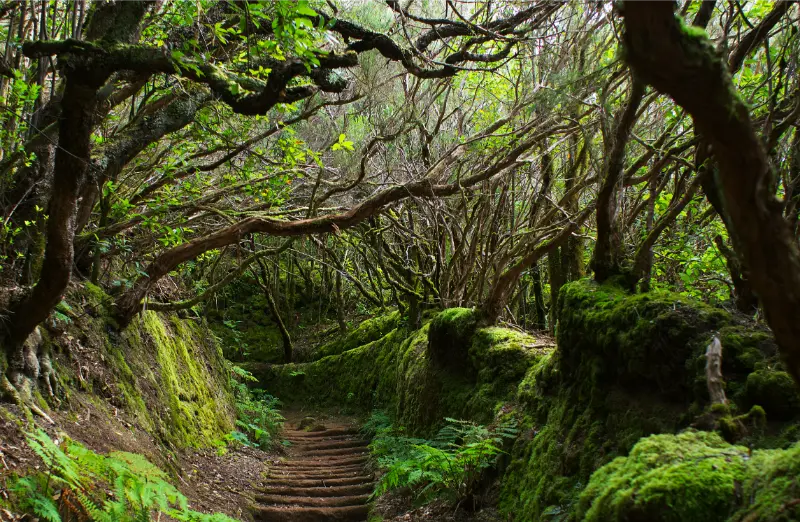
This is not a casual add-on after a full beach day. I plan footwear, transport between trail endpoints and weather carefully. Wet stone can be slippery, and cloud in the upper forest may be very different from sunshine on the coast.
PR-TF 8 Afur–Taganana–Afur
For experienced hikers, the official PR-TF 8 description lists a demanding circular route of about 14.3 kilometres, around seven hours and substantial accumulated ascent and descent. It connects Afur, the Tamadite area, Taganana and the forest. I check current trail status before considering it.
I would not recommend this as a spontaneous holiday walk. Seven hours in steep terrain requires fitness, water, food, daylight and a stable forecast. If I mainly want Taganana, a shorter walk plus village time is often the better travel experience.
Food in Taganana
The coast is known for simple fish restaurants, while the village and surrounding Anaga area also connect with traditional wine and agricultural products. I eat where it fits the day rather than driving back to the city for a famous restaurant.
My food guide explains Canarian basics. In a small community, I am especially patient when service is slower; the point of the visit is not resort efficiency.
Driving to Taganana
The roads through Anaga are narrow, winding and scenic. I use my Tenerife driving guide as a reminder to keep speeds low, use legal parking and avoid stopping on blind bends. I also check fuel before entering the massif rather than expecting a station in every village.
If I am uncomfortable with mountain roads, I do not force a rental-car day simply because the route is famous. Public transport or an organised excursion can make the visit more relaxing.
Visiting by bus
Taganana is served by TITSA, and buses are a realistic way to reach the village without driving. Schedules are less frequent than urban routes, so I check the current timetable and know my return option before leaving Santa Cruz or La Laguna. My no-car guide covers the practical side of using TITSA.
A bus also changes the day positively: I can look out at the mountains instead of concentrating on bends and parking. The trade-off is that hopping between all three beaches becomes less flexible, so I choose priorities.
Taganana and Anaga in one day
I combine Taganana with one or two Anaga viewpoints or a short laurel-forest walk. My Anaga Rural Park guide explains the broader geography. I do not attempt every major trail, viewpoint and beach in a single day.

A realistic plan could be forest walk in the morning, Taganana for lunch and one coastal beach afterward. That gives the landscape time to change naturally as I descend from cloud forest to the Atlantic.
When to go
I prefer a weekday morning outside the busiest holiday periods, but weather matters more than calendar. Anaga can be cloudy or wet even when the south is sunny. That is normal. I bring a light waterproof layer and do not cancel simply because the high forest is misty.
Strong rain, wind or official warnings are different. I follow closures and do not enter ravines or exposed trails during unsafe conditions. The coast can also be rough independently of the mountain weather.
Where to stay
Most visitors see Taganana as a day trip, but rural accommodation can suit hikers or travellers who specifically want Anaga evenings and early mornings. Services are limited compared with a resort, so I check food options, parking and transport before booking. I compare accommodation in Anaga and northeast Tenerife rather than assuming every property is close to Taganana itself.
For a first Tenerife trip, La Laguna or Santa Cruz is usually the easier base. Staying inside Anaga makes more sense when the rural setting is the purpose of the trip.
My ideal Taganana day
I leave early, stop at one high Anaga viewpoint, take a short forest walk, descend to Taganana, have lunch near the coast and choose either Roque de las Bodegas, Almáciga or Benijo depending on sea conditions and parking. Then I return before I am tired.

The most important choice is what to leave out. Anaga feels remote because the roads and terrain demand time. A day with fewer stops creates a stronger sense of place than a list of ten photo pins.
Frequently asked questions
Is Taganana worth visiting?
Yes, especially if you enjoy mountain scenery, traditional villages, dark-sand beaches and a slower rural atmosphere.
Can I drive to Taganana?
Yes, but the Anaga roads are winding and parking near the coast is limited. I drive slowly and use legal spaces only.
Can I reach Taganana by bus?
Yes. TITSA serves the village, but I check the current timetable because frequencies are more limited than in the city.
Which Taganana beach is best?
Benijo is the most dramatic, Almáciga is known for surf and Roque de las Bodegas is often the easiest for combining the coast with restaurants. Sea conditions can change the best choice.
How long do I need?
A full day is ideal if I want to include an Anaga forest stop, village time, lunch and one beach without rushing.
Respecting Anaga communities
I buy lunch or coffee locally when it fits the day, take litter away and avoid parking across gates or agricultural access. In small settlements, a single badly parked car can affect residents far more than it would in a resort car park. I also keep music and drone activity under control; quiet is part of the value of the place.
If a road, path or parking area is closed, I do not search for an unofficial bypass. Protected landscapes and rural communities function best when visitors accept that access sometimes changes.