
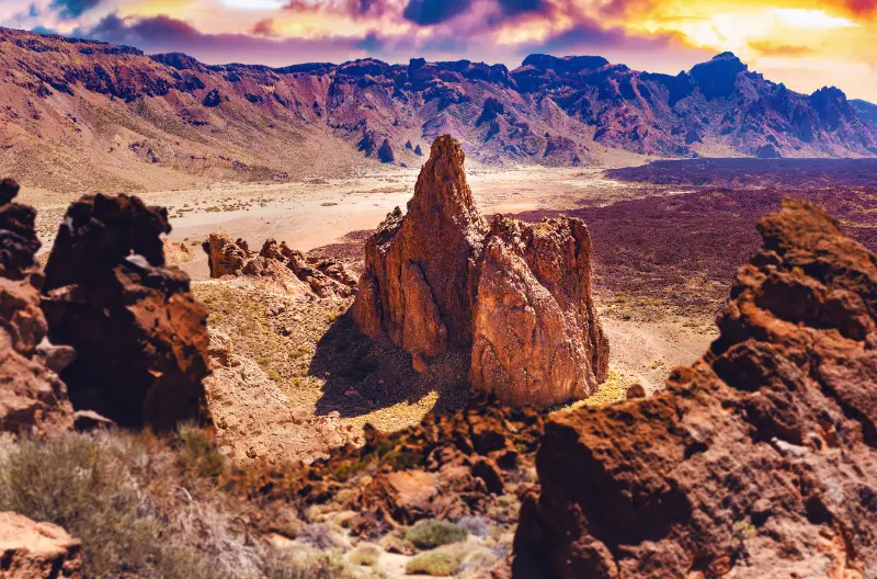
The Sámara trail is one of the Teide National Park walks I recommend when I want volcanic drama without an all-day mountain objective. The circular route starts at Mirador de Sámara and crosses dark pyroclastic terrain between Canary pines, with broad views toward Teide, Pico Viejo and younger volcanic cones.
Official Tenerife tourism information lists the loop at 5.1 km, about 2 hours 45 minutes, 308 metres of ascent and a maximum elevation of 2,103 metres. It is graded low difficulty and does not normally require authorisation, but altitude, sun and wind still deserve serious preparation.
Quick planning facts
| Trail | 13 Sámara |
|---|---|
| Start/finish | Mirador de Sámara |
| Distance | 5.1 km circular |
| Official duration | About 2 h 45 min |
| Difficulty | Low |
| Maximum elevation | 2,103 m |
| Ascent | About 308 m |
| Authorisation | Not normally required |
Why Sámara is one of my favourite short Teide walks
The Sámara trail gives me three classic Tenerife landscapes in one manageable loop: dark volcanic cones, Canary pine forest and views toward Teide and Pico Viejo. The official trail page lists a 5.1 km circular route with about 308 metres of ascent and a typical duration of 2 hours 45 minutes.
The difficulty is officially low, but altitude changes how a walk feels. The route runs between roughly 1,873 and 2,103 metres, so sun, wind and thinner air matter more than the modest distance suggests.
Official route facts and terrain
Turismo de Tenerife describes the trail as running over dark pyroclastic material, including lapilli and scoria, with small gradients that are generally easy to negotiate. The surface can still be loose, so I prefer hiking shoes over smooth-soled trainers.
An official detail I like is that no authorisation is required for trail 13 Sámara. That does not remove the need to respect temporary closures, fire restrictions or protected-area rules.
Starting at Mirador de Sámara
The route starts and ends at Mirador de Sámara. I arrive early because roadside trailheads can become awkward when many cars appear at the same time, and I never create a new parking space on vegetation or soft volcanic ground.
I take a few minutes at the viewpoint before walking. Seeing the line of cones and the scale of the western Teide landscape helps me understand what the trail is about.
Altitude, sun and wind
At more than 2,000 metres, UV exposure is intense even on cool days. I carry more water than I expect to drink, use sunscreen and bring a windproof layer. In winter I check for cold, ice or snow-related restrictions before driving up.
My Mount Teide guide explains altitude and weather planning in more detail, while Tenerife weather by month helps with seasonal expectations.
Photography and volcanic colours
Sámara is especially photogenic because black and rust-coloured cones contrast with green Canary pines and the pale summit landscape. Morning and late afternoon give the terrain more shape, but I prioritise safe daylight over chasing a perfect image.
I stay on the route even when a nearby cone looks easy to climb. Fragile volcanic surfaces recover slowly from repeated shortcuts.
Who I recommend it to
I recommend Sámara to travellers who want a real Teide National Park walk without committing to a summit-style day. It also works well for active families with older children who are comfortable on uneven ground and at altitude.

For an even easier introduction I compare it with Roques de García. For a harder high-level hike I look toward Guajara.
Official trail source
I plan with the official Sámara trail page, which provides distance, duration, elevation and authorisation status. On the day, I also check Teide National Park alerts and weather.
Protected-area rules can change temporarily because of fire risk, snow, maintenance or conservation. Current signage always outranks an older itinerary.
A simple half-day plan
- Drive up early and stop only at legal viewpoints.
- Walk the Sámara loop at a steady pace with water breaks.
- Have lunch or a picnic only where permitted.
- Continue to a different Teide viewpoint rather than adding another long hike.
- Descend before fatigue turns the mountain road into work.
This leaves margin for weather and makes the trail the centre of the day rather than one item in a rushed checklist.
How I fit it into a realistic Tenerife day
I treat the Sámara trail as part of a wider Teide National Park day rather than an isolated pin on the map. Tenerife looks compact, but mountain roads, parking searches and changing weather can turn short distances into slow travel. I decide in advance which stop is the priority and which stops are optional.
My preferred approach is to pair it with Roques de García, western Teide viewpoints or Santiago del Teide. That creates a day with contrast without spending most of the time in the car. I also keep one backup plan nearby in case wind, cloud, surf or temporary access restrictions change the experience.
Weather, clothing and microclimates
I never use a single Tenerife forecast for the whole island. North-coast cloud, Anaga mist, Teide sunshine and south-coast heat can all occur on the same day. I check the forecast for the exact municipality and, for mountain or coastal activities, I also look at wind and sea conditions.
Even on warm days I carry sun protection, water and a light layer. At higher elevations I add a windproof layer, while on the coast I bring footwear with grip because volcanic rock, wet steps and black sand can all be slippery or hot.
Responsible travel habits I use here
Small beaches, villages, viewpoints and trailheads are shared local spaces. I park only where it is legal, keep access to homes and farm tracks clear, take rubbish away and avoid turning narrow roads into informal photo stops. In protected areas I stay on the marked route and never collect volcanic material, plants or other natural objects.
I also prefer to support the area in a simple way: a coffee, lunch, market purchase or locally made product is often a better souvenir than something generic. Respectful travel is mostly about ordinary decisions that reduce pressure on places I want to remain enjoyable.
My backup plan when conditions are wrong
If the sea is rough, I do not force a swim. If a viewpoint is inside cloud, I move lower or switch to a village, museum or food stop. If parking is full, I continue to the next planned place rather than circling residential streets. This flexibility is especially useful in Tenerife because very different landscapes sit close together.
I build the day around one must-do experience and several optional stops. That structure produces better trips than trying to complete a rigid checklist, and it makes it easier to respond to closures, weather and local events without feeling that the day has failed.
Frequently asked questions
Do I need a permit for the Sámara trail?
The official trail page states that authorisation is not required, although temporary closures or restrictions can still apply.
Is Sámara suitable for beginners?
It is officially graded low difficulty, but beginners should still be comfortable with loose volcanic terrain, sun and altitude.
How long does it take?
The official estimate is about 2 hours 45 minutes for the 5.1 km loop.
Can I see Teide from the trail?
Yes. The route offers broad views of Teide, Pico Viejo and surrounding volcanic cones.

What shoes should I wear?
I use hiking shoes or trail shoes with grip because lapilli and scoria can be loose underfoot.
Questions I ask myself before I go
I check four things before leaving: current access, exact weather, realistic travel time and what I will do if the first plan fails. Tenerife is an easy island to underestimate because distances look short on a map. A mountain road, coastal traffic or a full car park can add far more time than expected.
I also decide whether the destination is the purpose of the day or simply one stop. When it is the main purpose, I leave enough time to experience it slowly. When it is secondary, I set a clear limit so the rest of the itinerary does not become rushed.
What makes this worth adding to a longer Tenerife trip
The strongest Tenerife itineraries mix famous landmarks with smaller places and experiences. Teide, Anaga and the main beaches explain the island at a large scale, while a local pool, rural trail, village festival or food tradition explains how people actually use and understand the landscape.
I therefore do not judge a place only by the number of attractions. A short viewpoint can be valuable if it helps me read the geography; a small village can be memorable if I slow down for lunch; a modest trail can reveal volcanic history better than a long drive through the same area.
Practical travel habits that improve the day
I download maps or save the route before entering areas with weaker mobile coverage. I start with a full bottle of water, keep a layer in the car, carry some cash for small local businesses and avoid planning every meal at the most obvious tourist time. These are small habits, but they make rural Tenerife much easier.
I also leave more space between stops than a navigation app suggests. That time absorbs photo stops, roadworks, wrong turns and simple curiosity. The best travel days on Tenerife often improve when I have enough margin to stop somewhere I had not planned.
My final take
Sámara is my kind of Teide walk: short enough to fit a flexible day, but visually strong enough to feel like a genuine mountain experience. I give it respect for altitude and weather, stay on the route and let the volcanic landscape provide the drama.