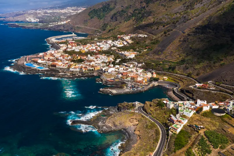
La Caleta de Interián is a useful stop for travellers who want to see the northwest coast between Garachico and Los Silos at a slower, more local scale. The settlement is unusual because it is administratively shared by the municipalities of Los Silos and Garachico. It has a fishing-coast character, a compact street grid, a beach area and access to a rocky shoreline where traditional domestic salt-making has survived.
The Los Silos municipality describes La Caleta as a seafaring neighbourhood between the two municipalities. Its coastal information highlights a roughly five-kilometre Los Silos shoreline of rocky points, small beaches and natural pools, with traditional salt pans around La Caleta de Interián where salt is still produced using natural rock depressions.
Quick planning facts
| Location | Northwest Tenerife, between Garachico and Los Silos |
|---|---|
| Municipalities | Shared by Garachico and Los Silos |
| Character | Local coastal neighbourhood |
| Best for | Seafront walking, local atmosphere, salt-making heritage, quiet coast |
| Nearby anchors | Garachico, Los Silos, Buenavista del Norte |
| Swimming | Condition-dependent Atlantic coast |
| Ideal visit | 1–3 hours, longer with the coastal walk |
What I come here for
I do not come to La Caleta expecting a polished resort. I come for the relationship between streets, fishing history and a rugged lava coast. The neighbourhood works especially well as a pause between the major historic centre of Garachico and the quieter Isla Baja landscapes around Los Silos and Buenavista.
That contrast is useful in a road trip. Garachico has major architecture and the famous El Caletón pools; La Caleta de Interián feels more everyday. My Garachico guide and Los Silos guide show how I would build the wider day.
The coastal walk
Los Silos promotes walking along its coast from La Caleta de Interián toward Buenavista del Norte. I like this as an alternative to driving between every small stop. The shoreline is mostly volcanic and rocky, with natural pools and small bathing areas appearing between points and inlets.
I keep the sea on the safe side of any barriers and do not climb wet rocks for a photograph. North-coast swell can be powerful even when the weather is calm. The Tenerife safety guide explains the ocean rules I use around charcos and open coast.
Traditional salt pans
One of the most distinctive details is the presence of domestic salt pans. The municipality explains that salt is made traditionally using natural hollows in the coastal rock. I treat these as cultural heritage rather than props: I do not step into working pans, move stones or touch salt unless invited by someone responsible for the site.
This small-scale practice connects the neighbourhood to a long history of making use of coastal resources. It is exactly the kind of detail that can disappear if visitors see the coast only as somewhere to swim.
San Andrés and local history
On the Garachico side, the Parish of San Andrés Apóstol reflects the settlement’s long history. Municipal tourism information traces an earlier hermitage to 1582, with later enlargements and a twentieth-century tower. I would treat the church as a place of worship first and a visitor sight second, checking whether it is open rather than assuming access.

Swimming: my conservative approach
I never generalise north-coast swimming conditions. A bay that looks calm in a photograph can be rough on a different tide or swell. I look for designated access, local signage and the behaviour of the water over several minutes. If waves are washing over rocks or people are standing too close to surge zones, I keep the visit to the promenade and views.
For a more structured swimming option nearby, Garachico’s El Caletón is easier to understand when it is officially open and conditions permit, but even natural pools require caution.
Where to eat and how long to stay
I would allow time for a coffee or simple meal rather than schedule La Caleta as a five-minute photo stop. Small coastal places often make more sense when I sit down long enough to watch the working rhythm of the neighbourhood. Opening times vary, so I do not arrive late assuming every kitchen will still be serving.
Official sources I use
For the neighbourhood background I check Los Silos municipality’s La Caleta de Interián page. For the coastal route, natural pools and salt-pan context I use the municipal Los Silos coast guide. These local pages are more useful than generic resort descriptions because they explain the specific character of the area.

How I fit it into a Tenerife itinerary
I would not cross the island just to collect a quick photograph of La Caleta de Interián. I place it inside a coherent Isla Baja and northwest Tenerife day, give it enough time to understand the setting and then add only one or two nearby stops. This approach matters in Tenerife because mountain roads, parking and microclimates can turn a short distance into a slow journey. It also makes small villages and local neighbourhoods feel less like attractions and more like places with their own rhythm.
A sensible cluster is Garachico, Los Silos and Buenavista del Norte. I check the route before leaving, save the main parking or bus information offline and keep one optional stop that can be removed. For the wider area, I use my Los Silos guide so the day has a clear geographic logic instead of zig-zagging across the island.
Driving, buses and parking strategy
On rural roads I assume the final kilometres will take longer than navigation apps suggest. I keep to my lane, use safe pull-outs only, and never stop on a bend simply because a viewpoint looks attractive. If the destination has limited parking, arriving earlier is usually more useful than trying to find a “secret” space. I also avoid blocking house entrances, agricultural tracks, bus stops and emergency access.
Public transport can be a good option for some Isla Baja and northwest Tenerife days, but I verify the current TITSA timetable rather than relying on an old screenshot or blog. I identify the final practical return service before starting a walk. My Tenerife bus guide explains the ten+ system and the planning habits I use when I travel without a car.
Weather and what I carry
I pack for the exact environment rather than for the temperature at my hotel. In the north and in Anaga, cloud, wind and light rain can appear even when the south is sunny. On the coast, the Atlantic can be rough despite warm air temperatures. My basic kit is water, sun protection, a charged phone, a light layer and footwear appropriate to the surface. For rural walks I add a thin waterproof layer and a little more water than I think I will need.
The island-wide forecast is only a starting point. I compare the coast, the hills and higher elevations separately and use my Tenerife weather by month guide to understand why the same day can feel very different across the island.
Responsible travel in a lived-in place
La Caleta de Interián is not a theme park. I keep noise low near homes, stay on marked paths, take rubbish away and ask before photographing people at close range. In agricultural areas I never enter terraces or fields to improve a photograph. Small decisions like buying a coffee, lunch or local product from an open business can also make the visit more connected to the community without turning local life into a performance for visitors.
I also treat closures and temporary restrictions as part of the destination, not an inconvenience to bypass. Fire risk, storm damage, rockfall or maintenance can change access. If a road, beach or trail is closed, I use the backup plan and move on.
Where I would stay nearby
I would normally stay in Garachico, Los Silos or Buenavista rather than choose La Caleta solely for accommodation. Those bases give more restaurant and sightseeing options while keeping the coast close. For availability I would compare accommodation around Garachico or check places to stay in Los Silos.
Frequently asked questions
Is La Caleta de Interián in Garachico or Los Silos?
Both. The settlement is shared administratively between the two municipalities, which is one of its unusual features.

Is it worth a dedicated day?
For most first-time visitors, I would include it in a northwest day rather than spend an entire day only here. Slow travellers staying in Isla Baja may happily return for coastal walks.
Can I walk toward Buenavista?
Los Silos promotes a coastal walking route from La Caleta toward Buenavista del Norte. I still check current path conditions and daylight before setting out.
Final thoughts
La Caleta de Interián is not trying to compete with Tenerife’s headline attractions. That is exactly why I like it in a balanced itinerary. It gives the northwest coast a human scale: streets, a parish church, a rugged shore, salt pans and a long walk toward quieter parts of Isla Baja.
A slower way to experience the area
I leave room for unplanned time because the best part of rural Tenerife is often not the named attraction. A cloud opening over a ridge, a short conversation in a bar, a view from a legal pull-out or the smell of wet forest can become the memory of the day. If every fifteen minutes is assigned to a stop, I end up watching the clock instead of the place.
I also avoid building two demanding mountain objectives into the same day. Even if each route looks short, the combination of driving, elevation, parking and changing weather creates fatigue. One main walk plus one village or viewpoint is usually my preferred balance.
Navigation and phone coverage
I download the route and essential map area before leaving accommodation. Mountain valleys can have patchy mobile coverage, and battery drains faster when a phone searches constantly for signal. I carry a power bank on longer days and keep the official trail name or destination written down so I can ask for help clearly if needed.
For hikes, I use official signed routes as the primary reference and treat community GPX tracks as secondary information. A line on a mapping app may cross private land, an old path or a closed section. If signage and the downloaded track disagree, I stop and reassess rather than force the digital route.
Food, water and toilets
Small villages are not guaranteed service stations. I carry enough water to complete the main activity even if the local bar is closed, and I use toilets when I have a legitimate opportunity rather than assuming the next viewpoint will have facilities. I also bring a small rubbish bag because bins are limited on many rural routes.
When a village restaurant is open, I prefer to eat there rather than carry an elaborate picnic into a fragile landscape. It supports a local business and gives the day a natural pause. I still carry emergency snacks so a closed kitchen never becomes a safety problem.