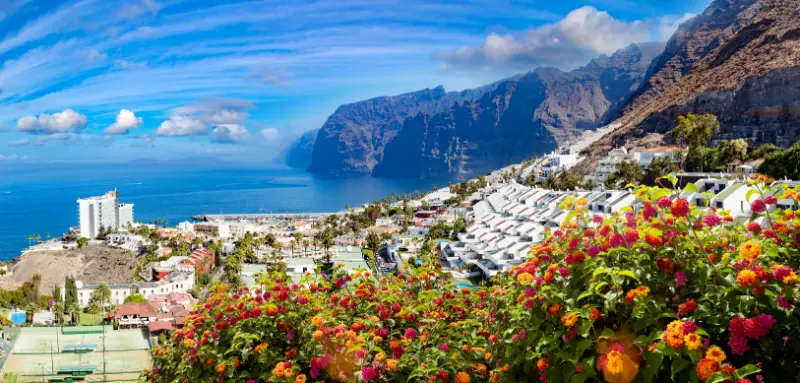
Mirador de Archipenque is the west-coast viewpoint I use to understand Los Gigantes before seeing the cliffs from sea level. The roadside platform looks across Puerto de Santiago toward the giant basalt walls, with La Gomera often visible on the horizon.
It is especially popular around sunset, but the practical details matter: official tourism information lists parking and adapted access, while noting that there is no bus stop directly at the viewpoint.
Quick planning facts
| Location | TF-454, Santiago del Teide |
|---|---|
| Best view | Los Gigantes cliffs and Puerto de Santiago |
| Sunset | Excellent on clear evenings |
| Parking | Yes |
| Bus stop at viewpoint | No |
| Adapted access | Yes |
| Interpretation panel | Yes |
| Combine with | Los Gigantes, Puerto de Santiago, Playa de la Arena |
Why the viewpoint matters
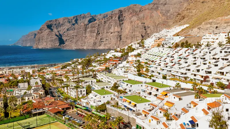
Mirador de Archipenque is one of the easiest places to understand the scale of Los Gigantes before going down to the coast. From the roadside platform I can see the cliffs, Puerto de Santiago, the marina and, in clear conditions, La Gomera across the channel.
The viewpoint is especially strong near sunset, when the western light reaches the cliffs and La Gomera often appears as a dark silhouette. I still prefer to arrive early because sunset is also when parking pressure increases.
Official access details
Turismo de Tenerife places the viewpoint on the TF-454 around kilometre 6 in Santiago del Teide. The official listing indicates parking, adapted access and an interpretation panel, but no bus stop directly at the viewpoint.
That last point matters for no-car travellers. I would not build a public-transport plan around being dropped at the exact platform; instead I use nearby Puerto de Santiago as the practical base.
Sunset planning
I arrive well before sunset, not at the final minute. That gives me time to park legally, choose a safe position and watch the changing light rather than creating stress on a busy road.
I never stop outside designated spaces or stand in the carriageway for a photograph. The view is not worth creating a traffic hazard.
What I can see
The main subject is the Acantilado de Los Gigantes, rising dramatically from the sea. Below, Puerto de Santiago and its marina provide scale, while Punta de Teno and its lighthouse can be visible farther along the coast.
On exceptionally clear days the view across to La Gomera is one of the best reminders that Tenerife is part of an archipelago rather than an isolated island.
Combining the viewpoint with Los Gigantes
I use Archipenque as the overview before or after spending time at sea level. My Los Gigantes guide covers the harbour, boat trips, beaches and practical planning.
If I am whale watching, I prefer the viewpoint after the boat trip when I can recognise the coastline from above.
Photography without overcomplicating it
A phone or normal travel lens is enough. I expose for the sky at sunset and accept that the cliffs may become darker silhouettes rather than trying to force every detail into one frame.
I also take a wider image that includes the town and sea because it explains scale better than a tight cliff crop.
Official source
I use the official Mirador de Archipenque page for road location, parking, accessibility and interpretation facilities.
I check local traffic and weather separately, especially around sunset and peak holiday periods.
How I fit it into a realistic Tenerife day
I treat Mirador de Archipenque as part of a wider Santiago del Teide and the west coast day rather than as an isolated pin on the map. Tenerife is compact on paper, but steep roads, parking, microclimates and slow village streets can make a short distance take longer than expected. I choose one priority experience and let the rest of the day support it.
My usual pairing is Los Gigantes harbour, Puerto de Santiago, Playa de la Arena or a whale-watching trip. I avoid building a six-stop checklist because the best small places on Tenerife reward unhurried time: a coffee, a coastal walk, a viewpoint or simply watching local life for half an hour often adds more than another rushed attraction.
Weather and microclimates I plan for
I never use a single island-wide weather forecast. The east coast can be bright while the north is under cloud, and a village at 300 or 500 metres can feel much cooler than a beach only a few kilometres away. Before leaving I check the exact municipality, wind and, for swimming, sea conditions.
I carry water, sun protection and a light layer even on apparently simple days. Tenerife rewards flexibility: if cloud blocks a viewpoint, I move lower; if the sea becomes rough, I turn the day into a walk, lunch or village visit instead of forcing a swim.
Driving, parking and public transport
For smaller places I zoom into the road layout before departure and identify where I can legally leave the car. I never block house entrances, farm tracks, bus stops or emergency access. If the available spaces are full, I continue to my backup stop rather than circling narrow residential streets.
When I use buses, I verify the current TITSA timetable on the day. Frequencies away from the main tourist corridors can be limited, and the last useful connection may be earlier than expected. My Tenerife bus guide explains the planning method I use for rural and coastal stops.
A slower way to experience the area
The places in this guide make more sense when I pay attention to landscape rather than only attractions. Terraces, old roads, lava, ravines, traditional houses and the relationship between coast and mid-altitude settlements explain why Tenerife developed the way it did.
I also try to spend locally: a bakery, small café, market purchase or family restaurant creates a better connection with the area than a generic souvenir. I remain respectful around homes and churches, keep noise low in residential lanes and take all rubbish away.
What I would combine nearby
I keep the day geographically coherent. Around Santiago del Teide and the west coast, I would combine Mirador de Archipenque with Los Gigantes harbour, Puerto de Santiago, Playa de la Arena or a whale-watching trip, choosing only two or three substantial stops. This keeps driving time under control and makes it easier to adapt when weather or access changes.
If I am staying elsewhere on the island, I group several places in the same zone rather than crossing Tenerife repeatedly. That is one of the simplest ways to make a one-week or two-week itinerary feel calmer and more local.
My backup plan
Every Tenerife day has a Plan B. For a beach I choose a nearby town or café; for a viewpoint I identify a lower-elevation stop; for a hike I choose a short signed walk or cultural visit. This matters because wind, surf, cloud, closures and parking can change without making the whole day a failure.
I also save offline maps and enough information to navigate without a signal. In rural areas I do not rely on the assumption that mobile coverage will be perfect at every bend in the road.
Frequently asked questions
Is Archipenque good for sunset?
Yes. It is one of the classic west-coast sunset viewpoints, especially when La Gomera is visible.
Is there parking?
Yes, official information lists parking, but spaces can be busy around sunset.
Can I reach it directly by bus?
The official listing says there is no bus stop at the viewpoint itself.
Is the viewpoint accessible?
Adapted access is listed by Turismo de Tenerife.
What can I see?
The main views are the Los Gigantes cliffs, Puerto de Santiago and, in clear weather, La Gomera and the far western coast.
How I decide whether this stop belongs in my itinerary
I ask whether the place adds something different from the previous day. Tenerife can easily become a sequence of similar viewpoints or beaches if I plan from a list instead of from geography. I prefer contrast: coast after forest, heritage after a hike, or a quiet village after a major attraction.
I also compare the detour with the experience. A small stop that sits naturally on my route can be excellent; the same stop may not justify a two-hour cross-island drive. This is why I group days by area and protect time for unplanned discoveries.
Small mistakes I try to avoid
I do not trust travel times that ignore parking, mountain bends or finding the correct entrance. I do not leave water in the hotel because the plan looks short. I do not assume a café, toilet or ticket office will be open simply because an old article mentions it. And I never turn a closed gate or warning barrier into a challenge to get around.
Another common mistake is trying to reproduce a photograph exactly. Light, tide, cloud, vegetation and access all change. I use images for orientation, then accept the conditions I actually find. That approach is safer and usually creates a more genuine travel experience.
What I save on my phone before leaving
I save the exact destination, an offline map, the official information page and one backup stop in the same area. For a hike I also save the route file or map, emergency information and the latest access notice. For a beach I check sea conditions and identify a nearby non-swimming alternative.
This simple preparation matters most in rural Tenerife, where a weak signal or a closed road can otherwise turn a small change into a long detour. It also lets me spend less time looking at my phone once I arrive.
Responsible travel details that matter
I stay on marked paths, never collect volcanic rocks or plants in protected areas, keep drones subject to current rules and avoid photographing people at close range without permission. In villages I remember that the photogenic doorway is somebody’s home and the narrow lane may be the only access for residents.
On the coast I keep away from unstable edges and do not approach blowholes or outer rocks during swell. I take rubbish away, avoid feeding wildlife and use established access rather than creating shortcuts through vegetation. These are small decisions, but repeated by many visitors they determine how well places cope with tourism.
My final take
Archipenque is a short stop with a huge visual payoff. I arrive early, park legally and use it to place Los Gigantes in context before exploring the harbour and coast below.